
Health, Monitoring & Air Quality Science
Scientific monitoring, public health information, smoke awareness, emissions analysis, and collaborative research help support healthier communities and evidence-based airshed management throughout the Bulkley Valley Lakes District.
Monitoring the BVLD Airshed
The Clean Air Plan supports regional monitoring systems, emissions inventories, scientific reporting, and public access to environmental information that helps communities better understand changing air quality conditions throughout the airshed.
Air Quality & Public Health
Fine particulate matter (PM2.5) remains one of the most significant air pollutants identified within the Bulkley Valley Lakes District Airshed Management Plan. PM2.5 is commonly associated with wildfire smoke, wood smoke, transportation emissions, industrial activity, open burning, dust, and other combustion sources.
Exposure to elevated particulate concentrations may contribute to respiratory irritation, cardiovascular stress, visibility reduction, and broader public health impacts — especially during wildfire smoke events and poor venting conditions.
Long-term scientific monitoring, public health communication, community awareness, emissions inventories, and collaborative regional planning remain essential components of healthier and more resilient communities.
Regional Monitoring & Scientific Resources
The BVLD Airshed Management Society and partner organizations support a growing network of monitoring systems, technical reports, wildfire smoke resources, AQHI guidance, emissions inventories, and community information platforms throughout the region.
Micro Emissions Inventory
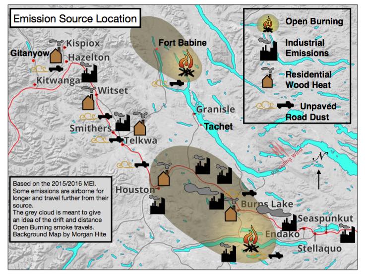
Regional micro emissions inventories help identify particulate sources, emissions patterns, seasonal trends, and cumulative air quality impacts throughout the Bulkley Valley Lakes District airshed.
Inventory analysis supports evidence-based planning, emissions reduction strategies, source attribution, and long-term airshed management initiatives identified within the Clean Air Plan.
Technical Inventory Report
Detailed scientific reporting and inventory analysis provide baseline information regarding emissions contributors, source characterization, seasonal impacts, and cumulative particulate loading throughout the region.
PurpleAir Regional Sensor Network
Community PM2.5 sensors provide real-time monitoring information related to smoke density, particulate concentrations, venting conditions, and changing regional air quality patterns.
UNBC Cyclone Monitoring Map
Regional monitoring systems and scientific mapping tools support improved public awareness, smoke tracking, wildfire monitoring, and long-term environmental analysis.
Health Messaging & Smoke Guidance
Health messaging resources provide information about PM2.5 exposure, wildfire smoke, AQHI guidance, respiratory protection strategies, and public health recommendations during poor air quality conditions.
Community Information Resources
Community resource pages include wildfire information, webcams, smoke forecasts, emergency preparedness tools, venting forecasts, and environmental monitoring links.
Health & Science Priorities
Monitoring systems, scientific collaboration, emissions inventories, public awareness, and evidence-based planning all contribute to healthier communities and long-term regional resilience.
PM2.5 Monitoring & Analysis
Support improved understanding of particulate pollution, smoke exposure, cumulative emissions, and changing regional air quality conditions.
Micro Emissions Inventories
Strengthen regional emissions inventories and source attribution analysis to support evidence-based policy and airshed planning.
Public Health Awareness
Improve public understanding of smoke impacts, AQHI guidance, wildfire preparedness, and exposure reduction strategies.
Collaborative Science
Encourage collaboration between researchers, monitoring agencies, Indigenous communities, governments, health authorities, and environmental organizations.
Health & Science Implementation Areas
Scientific monitoring, public health communication, emissions inventories, smoke preparedness, and collaborative environmental research all contribute to improved regional awareness and long-term airshed management.
PM2.5 & Fine Particulate Matter
PM2.5 refers to very small airborne particles commonly associated with wildfire smoke, residential wood smoke, transportation emissions, industrial activity, and combustion sources.
The BVLD Airshed Management Plan identifies PM2.5 as one of the most significant pollutants affecting regional air quality and public health.
Micro Emissions Inventories & Source Analysis
Micro emissions inventories help identify localized emissions sources, seasonal pollution patterns, cumulative particulate impacts, and airshed behaviour throughout the BVLD region.
Scientific inventory analysis supports evidence-based policy development, emissions reduction planning, regional monitoring priorities, and long-term implementation strategies identified within the Clean Air Plan.
Inventory reporting also strengthens regional understanding of PM2.5 contributors including residential wood smoke, transportation activity, industrial emissions, open burning, dust, and wildfire smoke.
Wildfire Smoke & Seasonal Air Quality Events
Wildfire smoke increasingly influences seasonal air quality conditions throughout northern British Columbia and the BVLD airshed region.
Monitoring systems, smoke forecasts, AQHI guidance, and preparedness resources help communities respond more safely during smoke events.
Community Sensor Networks
Low-cost sensor technology and community monitoring initiatives make air quality information more accessible throughout the airshed region.
Community sensors strengthen local awareness and support scientific reporting related to PM2.5 and smoke conditions.
Air Quality Health Index (AQHI)
The Air Quality Health Index provides public health guidance related to changing air quality conditions and pollution exposure risks.
AQHI systems help residents make informed decisions during periods of elevated smoke exposure and wildfire activity.
Research & Collaborative Monitoring
Universities, governments, Indigenous communities, environmental organizations, and health agencies all contribute to collaborative air quality research and monitoring throughout the BVLD airshed.
Long-term scientific collaboration strengthens environmental reporting, improves regional planning, and supports healthier communities.
Participate in the Clean Air Plan
The Clean Air Plan is intended to be a collaborative and evolving regional framework supported by governments, communities, industries, researchers, organizations, and residents throughout the airshed.
Stakeholders are encouraged to both report implementation actions and provide feedback that may help strengthen future updates, priorities, monitoring approaches, indicators, emissions inventories, and regional air quality strategies.
Health & Science Focus Areas
Monitoring systems, emissions inventories, scientific collaboration, public health awareness, and regional participation all contribute to long-term airshed resilience and cleaner air outcomes.
Participate in the Clean Air Plan
The Clean Air Plan is intended to be a collaborative and evolving regional framework supported by governments, communities, industries, researchers, organizations, and residents throughout the airshed.
Stakeholders are encouraged to both report implementation actions and provide feedback that may help strengthen future updates, priorities, indicators, monitoring approaches, and regional air quality strategies.